
Basic features
- TRS is a very intense low-pressure area, which will experience extremely strong winds, thick cloud cover, torrential rains, high waves, astronomically high tides and abnormally high rise of water level along the coast. It can cause extensive damage to life and property along the coast and at sea.
- It could cover an area of about 400 to 500 miles diameter.
| REGION | AREA | NAME | SEASON |
| North West Atlantic ocean | West Indies, Gulf of Mexico, Caribbean, Bahamas, Florida | Hurricane | June to November |
| North West Pacific ocean | South China sea, Philippines, Caroline islands, Taiwan | Typhoon or Baguios | May to November |
| North East Pacific ocean | Coastal area from Costa Rica to lower California | Hurricane or Cordonazo | June to October |
| South West Pacific ocean | Queensland coast | Hurricane | December to April |
| South West Indian ocean | Madagascar, African coast, Rodriguez, Mauritius, Mozambique channel | Cyclone | December to April |
| South East Indian ocean | NW Australia, Gulf of Carpentaria, | Willy-Willy | December to April |
| Arabian sea | Middle of Arabian sea | Cyclone | May, June, October and November |
| Bay of Bengal | Andaman & Nicobar islands, coast of India, Bangladesh, Myanmar, Sri Lanka | Cyclone | May and October to December |
Formation
- It normally develops in open sea where the air mass can accumulate large amount of water vapour.
- The local sea temperature should be more than 26°C, which will help in substantial evaporation from the sea surface and thus considerably increase the RH. The sea temperature in the South Atlantic and South-East Pacific oceans is not sufficiently high, hence TRS is not formed in these regions.
- Prevailing winds should be weak so that the local air mass will not move away horizontally and thus it will be able to rise vertically upwards as stated below.
- High temperature will develop strong convection currents, which will cause the air mass to rise, cool adiabatically and result in heavy condensation and formation of clouds of large vertical extent.
- Heavy condensation will release large amount of latent heat, which will provide the required energy for the formation of TRS.
- Rising air will cause low pressure to develop at the sea surface. This would force the winds to blow in from the surrounding high-pressure areas.
- Fair amount of Coriolis force is necessary so that the wind blows along the isobars. Hence it is usually formed away from Equator i.e. from 5° to 20° N & S latitudes.
Movement
- It initially travels at a speed of about 10 knots in W or WNW direction in the Northern hemisphere and W or WSW direction in the Southern hemisphere.
- Gradually it takes a slightly parabolic path by shifting towards NW and SW directions in the respective hemispheres, and also increases speed.
- On reaching about 30° N & S latitudes it will tend to re-curve and move towards NE and SE directions respectively with speed increasing to about 15 to 20 knots. It finally dissipates in higher latitudes.
- The re-curvature occurs around a high pressure, which may be present near the coastal region. If the high pressure is further inland then the TRS may cross the coast without recurving, depending on its initial intensity, and dissipate over land due to lack of moisture and due to friction with land surface.
- The above movement may vary considerable in many cases.
Definitions
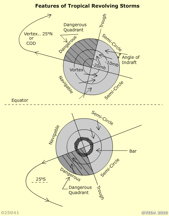
- Eye or Vortex : The central area of the TRS of diameter 4 to 30 miles which is relatively calm but with heavy confused seas. A patch of blue sky could be visible. At the actual centre there may be a thin downward stream of air (subsidence).
- Eye-wall : A ring around the eye of about 15 miles average width where the pressure gradient is very steep and winds of hurricane force blow in nearly circular path.
- Outer storm area : Area around the eye-wall extending upto about 200 miles.
- Track : The route over which the eye has already passed.
- Path : Predicted route over which the TRS is likely to travel.
- Trough : Line drawn through the eye and perpendicular to the track. As the TRS moves the pressure will fall ahead of the trough and rise behind it.
- Vertex or Cod : Westernmost longitude reached by the TRS before re-curving.
- Right hand semi-circle (RHSC) : Half of the TRS area which lies to right of the path when looking in the direction of the movement of the TRS.
- Left hand semi-circle (LHSC) : Half of the TRS area which lies to the left of the path.
- Dangerous semi-circle : RHSC in the Northern hemisphere and LHSC in the Southern hemisphere.
- Navigable semi-circle : Other than the dangerous semi-circle.
- Dangerous quadrant : Half of the dangerous semi-circle (quarter of the TRS area) lying ahead of the trough.
Weather
Pressure :
- Isobars are in a circular pattern with fairly high-pressure gradient.
- In the outer storm area the pressure drop may be slow and the semi-diurnal variation for the region may still be apparent.
- Within the eye-wall the pressure drop is very sharp and the semi-diurnal variation may not be visible.
- Within the eye the pressure may be 960 mb. or 20 to 60 mb. below normal for the region. In rare cases lower pressures have been reported.
Wind :
- The winds blow slightly across the isobars in anti-clockwise direction in the Northern hemisphere and clockwise direction in the Southern hemisphere.
- It makes an angle of in-draft of about 45° in the outer fringes of the TRS, and this angle gradually reduces to 0° in eye-wall i.e. it blows practically parallel to the isobars.
- Wind force may be 4 (about 15 knots) in the outer fringes, gradually increasing to 7 (about 30 knots) in the outer storm area and finally to 12 (60 to 90 knots) in the eye-wall. In rare cases wind speeds of up to 150 knots have been reported.
- If an observer is in the path of the TRS, then in the eye-wall, wind of hurricane force will be blowing from NEly direction in the Northern hemisphere and from SEly direction in the Southern hemisphere.
- In the eye the wind will suddenly die down and, as the trough passes over the observer, the wind will again blow with hurricane force from the opposite direction.
Temperature :
- It remains fairly steady in the full TRS area but it is little more than the normal temperature for the region, except that it will drop in heavy rain.
- In the center of eye temperature may rise due to adiabatic heating of the subsiding air.
Clouds :
- In outer fringes of TRS cirrus clouds will be observed to be pointing towards the eye.
- As the TRS approaches, clouds will gradually change to cirrostratus, altostratus, nimbostratus and finally in the eye-wall towering anvil-shaped cumulonimbus clouds will be observed.
- In the eye there may be very little cloud.
Precipitation :
- Continuous light rain will be experienced just outside the eye-wall.
- Within the eye-wall there will be torrential rain accompanied with thunder and lightning.
- In the eye there will be no rain due to absence of cloud.
Visibility : It is usually excellent just beyond the TRS area and starts deteriorating as the storm passes over the observer till it becomes poor in rain.
Storm surge or tidal wave : Hurricane winds in the eye-wall generate strong underwater currents and high waves which travel radially outwards. On reaching shallow waters near the coast they cause the water level to rise considerably which when combined with high tide could wreck havoc in the coastal regions. This effect may be noticed well ahead of a vigorous TRS because waves travel faster than the TRS itself and it may last till the TRS passes over.
Warning signs
- Swell : Violent winds in the eye-wall generate high swell which move radially outwards at much faster rate than the speed of the TRS. Hence it can be experienced nearly 1000 miles ahead of the TRS. Direction from where the swell is coming gives the earliest indication of the direction of the TRS provided there is no land in between.
- Pressure : Barometric reading should be corrected for index error, height above sea level, latitude and temperature, as applicable for the instrument used, and then corrected for the semi-diurnal variation given in the sailing direction of that region. This corrected reading is then compared with the normal pressure of that region as given in the isobaric map in the sailing direction. If the corrected pressure is 3 mb. below normal then TRS should be suspected. If it is 5 mb. below normal then TRS is in vicinity, may be about 200 miles away.
- Storm warnings : In accordance with the SOLAS convention every State is supposed to take the following actions :
- Issue warnings to ships, preferably in graphic form, about gales, storms and tropical cyclones.
- Issue, twice daily, preferably in graphic form, weather information suitable for shipping, containing data, analyses, warnings and forecasts of weather, waves and ice. NAVTEX or INMARSAT or HF DPT may be used for this purpose.
- Equip selected ships with tested instruments like barometer, barograph, psychrometer and sea temperature measuring apparatus. These ships shall take and transmit meteorological observations 4 times a day.
- Other signs :
- Cirrus clouds in the form of bands or filaments pointing towards the eye.
- Development of clouds from high to medium to low level types.
- Unusually clear visibility ahead of the TRS area.
- Red/Copper coloured sky at sunset.
- Increase of wind force as pressure falls.
- Rain squalls with increasing frequency.
- Increase in intensity of rain.
- Threatening dark clouds at the horizon.
- Frequent flashes of lightning at the horizon.
Actions when TRS is confirmed
- In accordance with the SOLAS convention, Master shall communicate free of cost, the following information, by all possible means, to the ships in the vicinity and the prescribed authorities stated in volume I of the Admiralty list of radio signals, either in plain language (preferably in English) or by means of International code of signals, and preceded by the safety signal (TTT or SAYCURITY) —
- Date, time (UCT) and position of the ship when TRS was observed.
- Barometric pressure.
- Barometric tendency during the past 3 hours.
- True wind direction and force.
- State of sea.
- Swell condition, true direction, period or length.
- True course and speed of the ship.
- Further observations may be made and transmitted every 1 to 3 hours as long as the ship is under the influence of the TRS.
- Obtain bearing of the eye and the semi-circle in which the ship is lying as follows :
- Heave to and face the wind.
- According to the Buys Ballot’s law if the pressure has dropped by 5 mb. below normal, the eye of TRS will lie 12 points to the right in the Northern hemisphere and to the left in the Southern hemisphere. If the pressure has dropped by 10 mb. below normal then it is 10 points and if it has dropped by 20 mb. then it is 8 points.
- If the ship is forward of the trough, and if the wind veers (changes direction clockwise) as observed for a period of at least 2 hours, then the ship is in the RHSC, and if the wind backs (changes direction anti-clockwise) then the ship is in the LHSC. This applies to both the hemispheres.
- If the ship is behind the trough i.e. if the ship is overtaking the TRS, then the same change in wind direction will indicate the opposite semi-circle.
- If the wind direction remains steady then the ship is on the path of the TRS.
- If the wind veers and then backs or vice-versa then apparently the TRS has shifted its path and hence the semi-circle has changed.
Avoiding action
- As a general rule a ship should not come within 200 miles of the eye.
- If the ship is in port or at anchorage, and a storm warning is received, make every effort to proceed to sea as far as possible, in deep waters, and then take actions as stated below.
- If the ship is at sea in the dangerous quadrant, then proceed at maximum speed keeping the wind 1 to 4 points on the starboard bow in the Northern hemisphere and on the port bow in the Southern hemisphere. Keep the wind 1 point on the bow if the ship’s speed < 12 knots and increase the angle for faster ships.
- Keep altering the course as the wind veers or backs depending on the hemisphere in which the ship is, till it is clear of the TRS area i.e. till the pressure starts rising.
- If sea room is not sufficient then heave to with wind on the bow as stated above.
- If the ship is on the path of the TRS or if it is in the navigable semi-circle, then proceed at maximum speed with the wind about 4 points on the starboard quarter in the Northern hemisphere and on the port quarter in the Southern hemisphere, altering course as the wind veers or backs depending on the hemisphere in which the ship is, till it is clear of the TRS area.