1) Introduction
In this module we will learn about the effect of wind and current on navigation and how to counteract the same. Winds, currents and hence their effects are variable and may change very quickly. We shall also learn to calculate the distance travelled, the course made good and the set and drift experienced by the vessel.
2) Wind and its effects
Leeway is the leeward motion of the vessel due to the effect of wind. It may be expressed as a distance, speed or angular difference between course steered and course made good through the water. Look at the figure below.
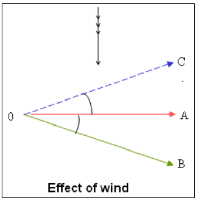
In the adjoining figure, say your vessel is steering the direction OA (090). The effect of the wind from north is to cause the vessel to make good the course OB. To counteract this effect of wind, the vessel must steer a course OC to make good the course OA.
On board a merchant ship as most of the above factors vary considerably, it is impractical to formulate a table to accurately tabulate the amount of leeway that should be given. This allowance is usually done on board on a ‘trial and error’ basis gaining knowledge with experience. In practice, it is impossible to calculate the effect of wind alone on the ship’s course and speed. It is usually a combination of both wind and current and the state of sea along with other factors.
When a vessel is underway, the wind that is experienced is the relative wind and not the TRUE WIND. For purpose of other calculations, it is important to know the true direction and speed of wind. This can be calculated using the wind triangle as follows:

Example I:
A ship is on course of 040 T at a speed of 15 knots. The apparent wind is 120T at a speed of 20kts. Find the direction and speed of True wind.
Draw a line representing the N-S direction and mark any point A on it. Mark off an angle 040 (T) at A and lay off the distance of 15 knots (AC) being the course and speed of the vessel.
Again at A, mark off an angle of 120 and lay off a distance of 20 knots (using the same scale – AB). BA will represent the apparent wind direction and speed. Join the points B & C. The direction BC will represent the true wind direction (For finding the direction, draw a N-S line through C and read off the angle at C between North and B) and length of vector BC will give you the true wind speed.
3) Current and its effects
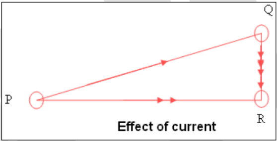
The horizontal motion of water over the surface of the earth is called current. The direction in which the water is moving is called the set and the rate at which it is moving is called the drift.
In the adjoining figure, PQ is the course and distance steered by the vessel. Expecting the vessel to be in position Q, a fix obtained showed the vessel to be at position R. Therefore the set and drift of the vessel is therefore from Q towards R. As the vessel has reached position R instead of Q, PR is the course and distance made good.
Some important points to remember
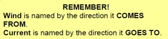
a) The set and drift of the current is always from D.R. position towards the fix. (i.e. it is always in the direction that it sets the ship).
b) Beam bearings are always on the course steered and never on the
course made good; while DISTANCE OFF when abeam is ALWAYS ON THE COURSE MADE GOOD.
c) Always calculate the rate of set and drift using the same time interval as that used for calculating the distance covered whether it is steered or made good.
d) Drift is always expressed in miles.
e) If required the rate of current can be obtained in knots by dividing the drift by the number of hours during which the drift occurred.
4) Practice calculations for distance, average speed and course made good
In this section of the module we will briefly run through the methods of calculating distances between two observed positions. These methods will be demonstrated by means of example.
Calculation of course & distance :
Sailing between two positions on the earth’s surface involves calculating the course and distance between them.
We all know that Earth is spherical in shape and hence the shortest distance traversed between two points on the Earth’s surface is the shorter arc of the great circle through those points. For practical purposes, where the distance between two places is less than 600 miles or so, it is considered to be a straight line and plane trigonometry can used to:
o Compute the course and distance between the two positions.
o Calculate the position arrived given the starting position, course and distance steamed. To facilitate easy calculation, the nautical tables gives you a set of tables known as the ‘Traverse Tables’ which gives ready solution of right angled triangles. We will solve one of the examples using this method also. When distances between two positions on earth’s surface exceed 600 nautical miles better accuracy will be obtained using the mercator sailing. For ocean voyages when the ship is travelling from one end of the ocean to the other the shortest distance between the two points will be a great circle and a brief on how to calculate the same is also given in this module.